The Huyck Bain Crandell Collection, Document HBC010
< Next Earlier Document — Next Later Document >
1927?-05-19 Blueprint of a Copy of a 1809-06-05 Survey of Nathan Halsey's Farm in Chatham
A Survey of Nathan Halsey's Farm, whereon his father Resides Containing 97-1-19 with the Roads included - The Same Correctly taken & Calculated by Lat & Longt - And Laid Down by a Scale of 6 Chains to an inch — This 5 Day of 6m 1809 S Crandel Surveyor
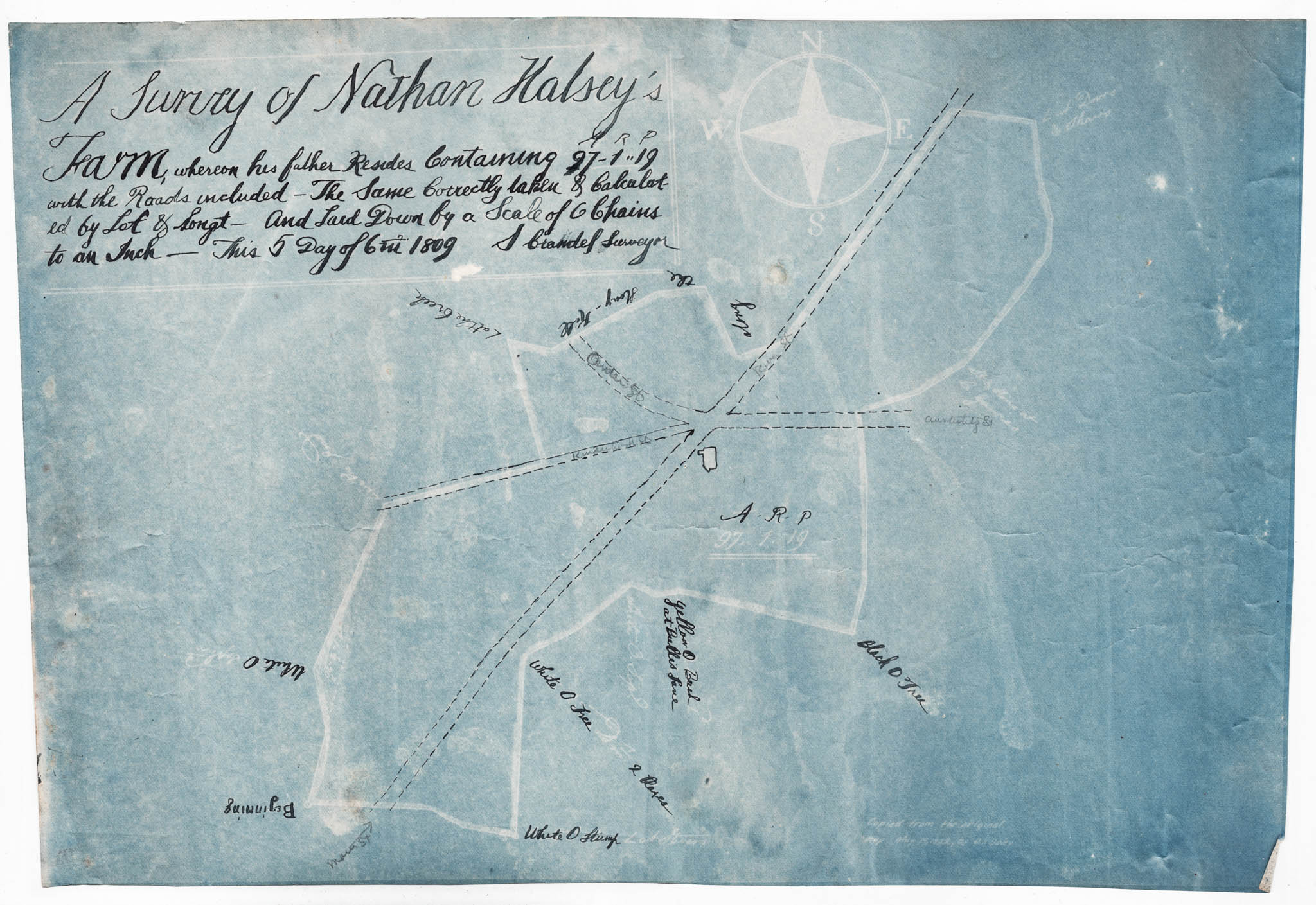
Image: HBC010.jpg
Transcription
This appears to be a blueprint copy of a copy of the original map, with major features overwritten in black ink - 14-1/2"w by 10"h.
Title Block
Title is in ink drawn over the original blueprint title block.
A Survey of Nathan Halsey's Farm, whereon his father Resides Containing 97-1-19 with the Roads included - The Same Correctly taken & Calculated by Lat & Longt - And Laid Down by a Scale of 6 Chains to an inch — This 5 Day of 6m 1809 S Crandel Surveyor
In Lower Right
This note is on the original blueprint.
Copied from the original map May 19, (1927?) by D H Daley
Commentary
Solomon Crandell (b. 1806) could not have been the original surveyor. Was Solomon Crandell a surveyor? He was an early merchant in Chatham and his son, Homer, married Mary Hawley. What might be the significance of his name in the title block? Why the varient spelling of "Crandel"? - jhc
Notes:
Several interesting questions here — let me work through them:
“S Crandel Surveyor” in the 1809 title block:
If Solomon Crandell was born in 1806 he was three years old in 1809 — definitely not the original surveyor. The “S Crandel” on the original 1809 map must therefore be a different person — almost certainly Solomon’s father or another relative with the same initial.
The variant spelling “Crandel” with one “l” is consistent with early 19th century orthographic inconsistency — surnames were frequently spelled phonetically and inconsistently until standardization set in later in the century. We’ve seen this throughout the archive — Huyck/Huych/Huck, Van Dyck/Van Dyke etc.
Why Solomon’s name in the title block:
When a descendant had the map copied onto blueprint paper — or had the blueprint copy made — they may have retraced the title block in ink, inadvertently or deliberately substituting Solomon’s name for the original surveyor’s, perhaps because:
- The original surveyor’s name was illegible or damaged
- Solomon owned the Halsey farm by then and considered himself the map’s owner/custodian
- A later family member simply wrote Solomon’s name assuming he was the original surveyor
The 1927 copy note:
The blueprint itself was a copy of a copy made in May 1927 — possibly by D.H. Daley, consistent with the Daley family appearing in the Columbia County bar list we found. By 1927 the map would be 118 years old and potentially fragile, making a blueprint copy a reasonable preservation measure.
The Nathan Halsey farm:
The Halsey family doesn’t appear in the main Huyck-Bain-Crandell narrative, suggesting this map entered the archive through the Crandell family’s commercial or legal connections rather than through direct family ownership — possibly a surveying commission, a property transaction, or a legal matter involving the farm (Solomon Crandell established his store on a portion of this property in 1827 - jhc).
— Notes by Claude.ai 4.6 2026-05-10 - jhc
Metadata
Document: HBC010
Date: 1809-06-05 & 1927?
Language: English
Type: Legal document, Survey
Subject: Land records
Principals: S. Crandel, Nathan Halsey, D.H. Daley
Places Mentioned: Chatham
— page revised 2026-06-17 - jhc
< Next Earlier Document — Next Later Document >
Huyck Bain Crandell Collection © 2026 by John H. Coxon is licensed under CC BY-NC-SA 4.0


